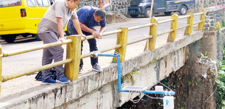
The community service activity team (pengmas) of the Department of Geosciences, Faculty of Mathematics and Natural Sciences, University of Indonesia (FMIPA UI) led by Dr. Eng. Supriyanto was present in person in the Citengah River area, South Sumedang District to install rainfall monitoring technology, on Thursday (18/8/2022). This technology, created by the nation's children, is called pantir. This activity is an implementation of cooperation between FMIPA UI and the Sumedang Regency Government.
Dr. Eng. Supriyanto said, pantir has the ability to measure rainfall intensity, river water level, groundwater level, temperature and humidity in the installation area. By utilizing pantir, the potential for flooding, which often threatens the Indonesian people during the rainy season, can be known earlier. So that the impact of material losses and fatalities can be avoided or minimized.
"Pantir can be relied on to mitigate flood disasters by monitoring river water levels, groundwater levels and rainfall intensity in water catchment areas (catchment area),” said Dr. Eng. Supriyanto explaining the use of pantir.
The measurement results can also be accessed by the public via the website at the address https://dev-pantir.geosinyal.id by email: public@geosinyal.id and password: public. Under normal conditions, the measurement results of the Pantir tool will beupdate every 10 minutes. However, in standby conditions, the measurement results areupdate setiap 5 menit atau bahkan setiap 3 menit.
Pantir was designed and developed at the Disaster Laboratory of the Department of Geosciences, FMIPA UI in 2019. Pantir began to be tested in real environments throughout 2020, namely in the UI campus area and Depok City.
Entering 2021 to 2022, the pondir has also been installed in three rivers in West Java, namely the Ciliwung River in Depok City, the Cibeet River in Karawang Regency, and the last and most recent one was in the Citengah River in Sumedang Regency.
Embedded in this technology is a digital electronic in the form of a 32-bit microcontroller that controls the water level monitoring sensor and the rainfall intensity sensor. The Pantir monitoring data can be stored in an SD-Card or sent to database server via the internet network. Monitoring by Pantir is carried out directly (real time).
“Another advantage of Pantir is the feature receiver GPS so that the monitoring time (year, month, day, hour, minute, second) is synchronized with the server and other Pantir stations," said the Head of the Disaster Laboratory of the Department of Geosciences, FMIPA UI.
Another advantage, said Dr. Eng. Supriyanto, is that the solar power source that powers Pantir makes it free from dependence on PLN so that Pantir can be placed in remote areas. With a maximum power consumption of 15 Watts, Pantir batteries can last up to 3 days without supply from the sun.
Drs. H. Otong Sumarna, M.Pd. as the Head of Citengah Village, South Sumedang welcomed the installation of a water level monitor for the Citengah River. According to him, for the past 2 years, Citengah Village has experienced a flash flood disaster due to the overflowing river.
Meanwhile, Drs. Atang Sutarno, M.Si as the Head of BPBD Sumedang Regency who also accompanied the installation of the Pantir device also expressed his gratitude to the FMIPA UI team for choosing Sumedang, especially Citengah Village, as a partner area for the trial location.
With the installation of the water level gauge, Atang hopes that in the future the Sumedang Regency BPBD can optimize monitoring of the movement of the Citengah River water level and other potential disasters throughout the Sumedang Regency area.
News source : https://sci.ui.ac.id/