|

|

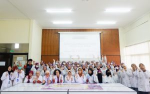
The Faculty of Mathematics and Natural Sciences, Universitas Indonesia (FMIPA UI), held the UI Geoscience Seminar (UIGS) X STARBORN Teaching 2025 with the theme “From Landscapes to Policy: The Contribution of Geoscience in Managing Natural Resources and the Environment.” The event, held at the Prof. Dr. G.A. Siwabessy Auditorium, UI Depok Campus, on Monday (November 3), featured Choirul Risman, S.Si., Environmental Impact Control Officer from the Ministry of Environment (KLH/BPLH), as the keynote speaker.
In his presentation, Choirul emphasized that geoscience plays a vital role in supporting national policies on natural resource and environmental management. According to him, understanding the characteristics of landscapes, ecoregions, and geological systems serves as the foundation for formulating data-driven policies.
“If geoscientists can read the Earth’s past, why not use that ability to save its future?” said Choirul before the participants.

He explained that geoscience is not only utilized for resource exploration but also plays a role in disaster mitigation, environmental conservation, and carrying capacity analysis. Through this scientific approach, development policies can be directed to align with the principles of sustainability.
In the lecture session, participants were introduced to the concept of ecoregions—areas characterized by similar climate, soil, water, and natural vegetation. Through geoscientific mapping and geospatial data, experts can accurately determine an environment’s carrying capacity and assimilative capacity—an essential step to ensure that development policies do not disrupt ecosystem balance.
Choirul also outlined the stages of environmental inventory, starting from data collection and classification, analysis, documentation, and evaluation. These data are used to assess ecosystem conditions and determine policy directions based on scientific evidence.
In addition, he highlighted the importance of calculating biodiversity indices, which involve monitoring protected species based on the Minister of Environment and Forestry Regulation No. P.106/2018 and the IUCN Red List. Choirul explained that the concepts of Important Bird Areas (IBA) and Key Biodiversity Areas (KBA) can serve as guidelines for both the government and the public in protecting wildlife habitats. He also noted that ecosystems such as peatlands, mangroves, and karst areas play a crucial role in maintaining water balance, storing carbon, and supporting human life.

The question-and-answer session was highly interactive, with many participants asking how to begin learning geospatial data. Choirul advised students to first understand the basics of Geographic Information Systems (GIS), map interpretation techniques, and the use of software such as QGIS and ArcGIS before moving on to more advanced spatial analysis.
As a form of appreciation, the speaker presented a gift to the most active participant. The event concluded with the presentation of a souvenir and a group photo session with all participants.
The UIGS X STARBORN Teaching 2025 event served as a platform for dialogue between academics and practitioners to strengthen understanding of the role of geoscience in environmental policymaking. Through this initiative, FMIPA UI aims to cultivate a generation of scientists capable of translating research findings into practical solutions for natural resource management in Indonesia.